
 Background
The Advanced Quantitative Precipitation Information (AQPI) system is a regional project that uses enhanced weather radar to track atmospheric rivers. AQPI was funded in 2016 by a grant from the California Department of Water Resources (DWR) Integrated Regional Water Management Program (IRWM) awarded to Sonoma Water and participating Bay Area agencies. National Oceanic and Atmospheric Administration (NOAA) and the Cooperative Institute for Research in the Atmosphere (CIRA) are building the AQPI system and delivering the AQPI end-product to these agencies. When completed, the goal of the AQPI system will be to provide X-Band and C-Band weather radar information that will increase the accuracy of weather forecasting and response systems throughout the Bay Area. Improved forecasting will assist flood agencies, emergency responders, wastewater plant managers, reservoir operators, and water managers in responding to extreme weather events in a timely fashion. A Local Partner Agency Committee (LPAC) has formed to develop the SF Bay AQPI framework for regional collaboration. The University of California San Diego, Scripps Institution of Oceanography, Center for Western Weather and Water Extremes (CW3E) is working with the LPAC member agencies to develop an operations plan and transition plan for the AQPI system. CW3E will operate the system when the DWR grant period ends in 2025.
The Problem
When big storms like atmospheric rivers hit California, current technology does not provide forecasters with the detailed information needed to inform reservoir operations, flood protection, combined sewer-stormwater systems and emergency preparedness. Accurate and timely precipitation information is critical for making decisions regarding public safety, infrastructure operations, and resource allocations.
Standard weather radars, originally designed to look up into Midwest thunderstorms, are often unable to give an accurate picture of what is happening just above the complex landscape of California’s coastal mountain ranges, where precipitation can be heaviest. Improved precipitation monitoring and prediction in the San Francisco Bay region can enhance public safety through early warning and storm tracking when hazardous weather events come onshore. That is the goal of AQPI.
- Real-Time Radar Display: Watch the radars in action now!
- CW3E AQPI website: https://cw3e.ucsd.edu/Projects/AQPI/main.html
- CIRA during the DWR funded phase of AQPI website: https://radarca.engr.colostate.edu/public
Radar Locations
When completed, the DWR funded project will have installed four X-Band radars and one C-Band radar that will cover most watersheds in the Bay Area (Figure A). Additional X-Band radars (not funded under this IRWM grant) will provide data to the AQPI system. See Figure A below for map with radars and coverage of the SF Bay Area AQPI system, when deployments are completed.
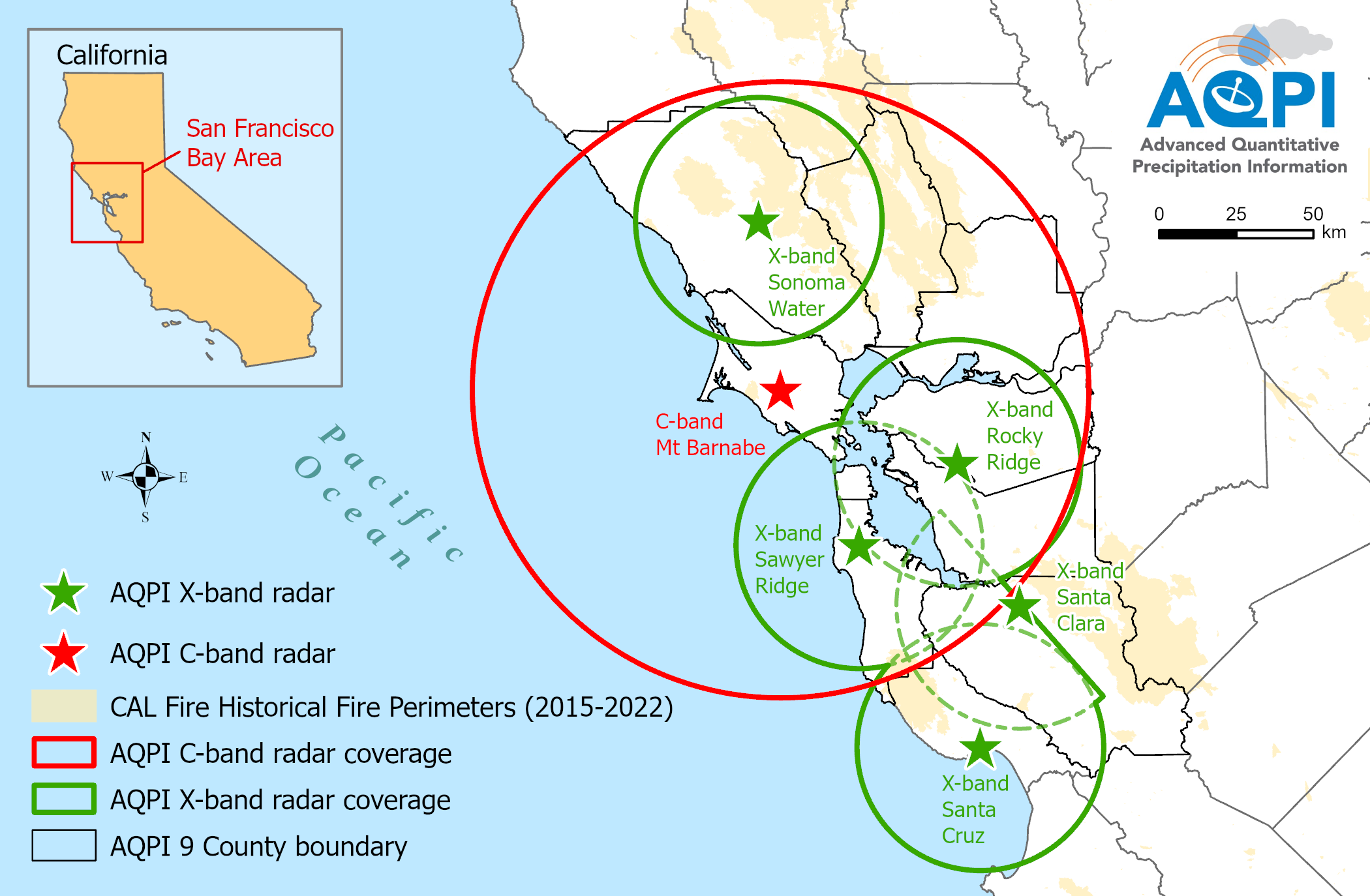
Figure A. Map of SF Bay Area AQPI X-Band and C-Band radar locations and coverage when deployments are completed.
Timeline for Radar Deployment
As of 2024 four X-Band radars are operational. These radars are located in Sonoma, Santa Clara, Contra Costa, and Santa Cruz Counties. One additional X-Band radar will be deployed in San Mateo in 2024. The C-Band Band radar is planned to be located on the Mt. Barnabe in Marin County in 2025. Radar locations include:
- Sonoma Water– Operating a temporary X-band radar since 2018, located near the Sonoma County Airport. A permanent X-Band radar was deployed in March 2023 on the same site, the Sonoma Water Treatment Plant.
- Valley Water – Since 2016 has operated a temporary X-Band radar at the Penitencia Water Treatment Plant. A permanent X-Band radar was deployed in July 2019 at the same location.
- San Francisco Public Utilities Commission (SFPUC) – Plans to deploy a permanent X-Band Radar on Sawyer Ridge in San Mateo County.
- East Bay Agencies Partnership – In December 2022, a partnership of East Bay agencies deployed an X-Band radar on Rocky Ridge, adjacent to the Las Trampas Wilderness area. The Rocky Ridge radar became operational in 2023. This partnership includes East Bay Municipal Utility District, East Bay Dischargers Authority, Contra Costa County Flood Control & Water Conservation District, Alameda County Flood Control & Water Conservation District, Alameda County Water District, and Zone 7 Water Agency.
- Santa Cruz County Flood Control and Water Conservation District deployed an X-Band radar on a county building in August 2022, funded through a grant from DWR’s Statewide Flood Emergency Response Grant program. The radar will send data to the SF Bay Area AQPI system.
- C-Band Radar - Regional partners are collaborating to deploy a C-Band radar on the peak of Barnabe Mountain in western Marin county. The C-Band radar will cover the Pacific Coast and also areas inland to complement the X-Band radars, improving precipitation and stream flow forecasting throughout the region.
SF Bay Area AQPI Benefits: AQPI Radar Imagery from Atmospheric River Storm
Flooding is a major concern in the Bay Area. See below in Figure B, where AQPI radar provides a more accurate picture of rainfall in Santa Rosa, to better assess the potential for flooding. Note - Warmest colors represent highest rain volume.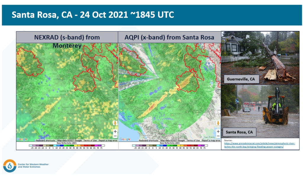
.gif)
Figure C NEXRAD vs AQPI Rocky Ridge
AQPI System Information
- Presentation: Advanced Quantitative Precipitation Information Building a State-of-the-Art Observation and Forecast System for the San Francisco Bay Area March 2024
- SF Bay Area AQPI Project Update January 2023
- NOAA AQPI https://psl.noaa.gov/aqpi/
- AQPI Additional Information
- Watch the radars in action now! Real-Time Radar Display
Project Meeting Agendas, Presentation and Notes
- Workplan for the Development of the AQPI Concept of Operations (CONOPS) Plan, 03/22/2022
- Bay Area Water Agencies Coalition (BAWAC) Presentation, 2/14/2022
- AQPI Bay Area Stakeholder Meeting Presentation, 2/15/2018
- AQPI Partners Kick-Off Meeting Agenda, 3/28/2016
- AQPI Partners Kick-Off Meeting Presentation, 3/28/2016
Additional Program Details
- San Francisco Bay Area Advanced Quantitative Precipitation Information System - Poster (PDF)
- San Francisco Bay Area Advanced Quantitative Precipitation Information System - Flier (PDF)
- AQPI May 2019 Update (PDF)
- AQPI Fact Sheet, April 2019 (PDF)
- AQPI Frequently Asked Questions, 2/15/18 (PDF)
Historical AQPI system informational documents previously published. These may not represent current information about AQPI.
April 2019 - AQPI Fact Sheet, (PDF)
February 2018 AQPI Frequently Asked Questions, (PDF)
June 2015 – AQPI Fact Sheet (PDF)
February 2015 –– BAFPAA Poster about AQPI (PDF)
Contact information:
Dale Roberts, Sonoma Water: Dale.Roberts@scwa.ca.gov
Rob Cifelli, NOAA Earth System Research Laboratory: Rob.Cifelli@noaa.gov
Visit: http://www.esrl.noaa.gov/psd/aqpi/