
After repeated catastrophic flooding through the 1950s, four flood detention reservoirs were built in the 1960s on Santa Rosa Creek, Matanzas Creek, Paulin Creek and Brush Creek. This integrated network of channels, detention reservoirs and flood facilities is collectively known as the Central Sonoma Watershed Project. With much of the infrastructure of the Central Sonoma Watershed Project reaching the end of its life expectancy, Sonoma Water and the Natural Resources Conservation Service began conducting a vulnerability assessment of the project facilities and plan to publish a new plan for restoration and improvement work to increase community resilience over the next 50 years.
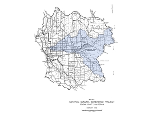
In 1958, the Sonoma County Flood Control and Water Conservation District (now Sonoma Water) and the USDA Soil Conservation Service (now Natural Resources Conservation Service) developed the Central Sonoma Watershed Work Plan to combat recurring flood damage in Sonoma County. The 1958 plan covered 163,000 acres of the Laguna de Santa Rosa, Mark West and Santa Rosa Creek watersheds (Figure 1); however, it explicitly focused on mitigating flooding in the 50,000-acre Santa Rosa Creek subwatershed through an integrated network of channels, detention reservoirs, and diversion structures that were completed between 1962 and 1988. Collectively, these flood facilities are known as the Central Sonoma Watershed Project. Sonoma Water maintains and operates the Central Sonoma Watershed Project, which includes facilities along Santa Rosa, Matanzas, Paulin, Spring, and Brush Creeks that protect the City of Santa Rosa and surrounding rural areas (Figure 2).
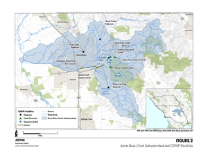 Figure 2. Project facilities and Santa Rosa Creek subwatershed map Figure 2. Project facilities and Santa Rosa Creek subwatershed map |
The Central Sonoma Watershed Project has exceeded its original 50-year design life and needs a comprehensive system-wide assessment to ensure it can reliably mitigate flood hazards in Santa Rosa and the surrounding unincorporated areas for future generations. Given the age of the Central Sonoma Watershed Project facilities, development and land-use changes that have occurred over the last 60 years, population growth, and newly available seismic risk and future climate data, Sonoma Water has entered into a cooperative funding agreement with the Natural Resources Conservation Service to conduct a vulnerability assessment of the facilities and to develop a new Watershed Plan – Environmental Document under the Public Law 83-566 Program. The purpose of the watershed plan is to identify and evaluate feasible alternatives that restore or improve flood protection and mitigate vulnerabilities to increase community resilience over the next 50 years. The watershed plan will document potential costs, benefits and environmental impacts of the alternatives.
As the federal lead agency, Natural Resources Conservation Service will assist Sonoma Water and publish a combined Watershed Plan – Environmental Document that complies with the National Environmental Policy Act. Sonoma Water will complete a separate California Environmental Quality Act, AB 52 and state and federal regulatory permit process.
The Central Sonoma Watershed project includes the flood protection reservoirs listed below that were built in the late 1960s to reduce flooding in the Santa Rosa area.
Piner Creek Reservoir (on Paulin Creek) - This reservoir temporarily stores up to 120 acre-feet of stormwater and is in the Chanate area of northern Santa Rosa off Paulin Creek. The dam was completed in 1964 and consists of a 145-foot-long main earthen embankment across Paulin Creek, an adjacent saddle dam earthen embankment and both a principal and auxiliary spillway structures.
Brush Creek Reservoir - 115 acre-feet can be stored in the Brush Creek Reservoir in Rincon Valley. Brush Creek Dam, which was completed in 1962, includes a 900-foot-long earthen embankment dam, and principal and auxiliary spillway structures.
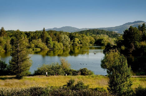 Santa Rosa Creek Reservoir (Spring Lake) – This reservoir in eastern Santa Rosa can store up to 3,735 acre-feet and includes the Spring Creek Diversion and Diversion Channel, as well as the Santa Rosa Creek Diversion and Diversion Channel.
From 1961 to 1964, Sonoma Water constructed Spring Lake as a flood control reservoir and another element of the Central Sonoma Watershed Project. The reservoir, one of Sonoma Water’s most ambitious flood control projects, consists of three earthen dams, two concrete spillways, a diversion structure and conveyance channels. The project diverts floodwaters from Spring Creek and Santa Rosa Creek into Spring Lake, mitigating flood risk to downtown Santa Rosa by temporarily storing flood waters.
In 1958, the project was designed to temporarily store the volume of water generated by a 100-year storm event (in other words, a storm that, based on 1958 records, had a 1 in 100 - or 1 percent - chance of occurring in any year). Only once since the lake's construction, in 1986, has flooding been so severe as to exceed Spring Lake's capacity and activate the emergency spillway.
In 1974, Sonoma Water began plans to develop the land surrounding the reservoir into parkland. Today, Spring Lake Park is one of the most popular recreation areas in Sonoma County. The park's 320 acres accommodate a 72-acre lake, a 3-acre swimming lagoon, and miles of walking, hiking, and horseback-riding trails. The park also includes a visitors' center, campsites, picnic areas, and boating facilities. Under a contract with Sonoma Water, the Sonoma County Regional Parks Department operates Spring Lake Park.
Matanzas Creek Reservoir – Completed in 1964, Matanzas Creek Dam forms the Matanzas Creek Reservoir where 1,445 acre-feet can be stored to the southeast of Santa Rosa in Bennett Valley. The dam consists of a main 685-foot-long earthen embankment across Matanzas Creek along with principal and auxiliary spillways. This reservoir is also the subject of a feasibility study with the Natural Resources Conservation Service to determine ways to improve the design of the dam and bring it into modern design standards.