View the latest Water Year webinar here.
Rainfall, Weather, and Streamflow Data
For information on Flood Forecasts & Emergencies, see here.
Current Water Year (Oct. 1 - Present) Precipitation Map (CA/NV River Forecast Center)
Weather Data and Statistics for Russian River Watershed (California Water Watch)
Sonoma Water OneRain
Lake Mendocino
Daily Reservoir Operations Data (CA Data Exchange Center / Department of Water Resources)
Scheduled Release Changes (CA Data Exchange Center / Department of Water Resources)
Lake Sonoma
Daily Reservoir Operations Data (CA Data Exchange Center / Department of Water Resources)
Scheduled Release Changes (CA Data Exchange Center / Department of Water Resources)
Weekly Water Supply Reservoir Levels for Lake Sonoma, Lake Mendocino and Lake Pillsbury
Current rainfall conditions (10/1/2025 – 7/12/2026)
Ukiah:
Average (1894-2025 water years): 36.05”
Current Water Year: 30.16” which is 83.6% of average
7-day rainfall total (7/6/26– 7/12/26): 0”
Santa Rosa:
Average (1950-2025 water years): 30.37"
Current Water Year: 26.02” which is 85.7% of average.
7-day rainfall total (7/6/26– 7/12/26): 0”
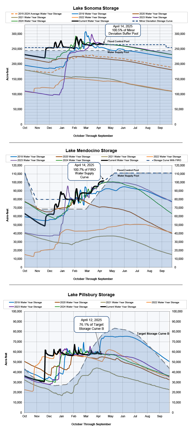
*Note that between March 1 and September 30 in Lake Mendocino, the Water Supply Pool is allowed to encroach into the Flood Control Pool and transitions to a higher operational level for the summer season. The "Target Water Supply Curve" represents the normal daily storage level for each day of the year. The daily storage levels were determined based on reservoir modeling of an average year under “Normal” water supply conditions as designated by the Russian River System hydrologic index. Categories of water supply conditions are based on criteria defined in the State Water Resources Control Board Decision 1610. These conditions establish the applicable instream flow requirements.
What is Forecast Informed Reservoir Operations (FIRO)?
Forecast Informed Reservoir Operations (FIRO) is a flexible water management approach that uses data from watershed monitoring and improved weather forecasting to help water managers selectively retain or release water from reservoirs for increased resilience to droughts and floods. FIRO applies emerging science and technology to optimize water resources and adapt to climate change without costly infrastructure. For more information, please visit SonomaWater.org/FIRO.
While reservoirs are full, it’s still important to save water
Visit Current Conditions for Sonoma County to view the U.S. Drought Monitor (USDM). These graphics show the location and intensity of drought.
Visit California Water Watch, enter your address to see how much rainfall your local area has received to date.
Conservation requirements are still in place in cities and water districts. Please visit your local water retailer to learn more about your conservation requirements.
Sonoma Water is currently operating under a Temporary Urgency Change Petition order from the State Water Resources Control Board. As of December 14, 2022, the minimum instream flow requirements in the Russian River are established based on Lake Mendocino storage levels. These temporary changes will remain in effect for 180 days. For more information, please visit SonomaWater.org/TUCP.
For more information on water-saving programs and rebates, visit theSonoma Marin Saving Water Partnership.
About Lake Sonoma and Lake Mendocino
Sonoma Water is the local cost-sharing partner for Lake Mendocino and Lake Sonoma, and determines the amount of water to be released from each reservoir when the lake levels are in the water supply pools. The U.S. Army Corps of Engineers determines the amount of water to be released when the lake levels are above the water supply pools and in the flood control pools.
Lake Mendocino relies on year-to-year rainfall to fill as well as water diverted from the Potter Valley Project. Lake Mendocino is a key drinking water source for the cities of Ukiah, Healdsburg, Cloverdale and Hopland, and also provides water to Sonoma Water’s Russian River water supply system. Water releases from Lake Mendocino support flows in the Russian River for the threatened Chinook salmon and steelhead trout during the fall and winter seasons.
Lake Sonoma is about four times larger than Lake Mendocino and can provide multiple years of water supply. Lake Sonoma relies on rainfall to fill and supports a dynamic and fragile ecosystem in Dry Creek that includes the endangered coho salmon and threatened steelhead trout. Lake Sonoma provides a majority of Sonoma Water's service area with its drinking water.
The Russian River is a managed river system with reservoir releases controlling river flows, especially throughout most of the summer and fall. When tributary stream flows are low, Sonoma Water releases water stored in the reservoirs to supplement the natural flows in the Russian River to provide adequate flows for water supply, recreation and aquatic habitat. A release from a reservoir can be categorized as being of ‘pass-through water’ or ‘stored water.’ The term ‘project water’ is often used instead of stored water and is used to describe water that is present because of the dam and reservoir project. Pass-through water is water flowing into the reservoir that is not stored in, but passes through, the reservoir. Project water releases to supplement the natural flows in the Russian River and Dry Creek are necessary to meet mandatory minimum streamflow requirements that exist for both of these watercourses.